 Oxenhope
Online
Oxenhope
Online

|
|
|
|
Taken from 'A Brief History of Oxenhope' published in 1996 by David Samuels with many local contributors. Proceeds from the sale of the book are to support the Multiple Sclerosis action groups.
Preface
Snippets from Past Oxenhope (David Samuels)
The History of Oxenhope (Mr R Hindley)
Daily Life (Mrs Freda Feather)
Life on a hill farm (Mr Joe 'Bodkin' Feather)
Mill Life (Mrs Lucy Shackleton)
Village Life (Mrs Winnie Cowgill)
Education (Mrs Pauline Sheffield)
The Parish Church of St. Mary the Virgin (Mrs Margaret Hindley)
Religious Life in Oxenhope (Mrs Norma Mackrell)
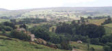
Oxenhope lies in a north-facing Pennine valley, around 650 feet (200m.) above sea level at its centre and up to 1450 feet (451m.) on its southern moors. It has heavy rainfall and comparatively snowy winters, though the 1980s and early '90s diverged from that description. This brief geographical introduction probably explains why Oxenhope has little recorded history, indeed none before 1086 - Domesday Book - and that even omitted to mention its name. It was then just one of the subordinate berewicks (sub-manors) of Bradford. Domesday Book gave their number, and a later list added names, including Oxenhope's, to a record of the same number, so it is reasonable to assume we were here at the earlier record.
The name Oxenhope is Old English for a recessed valley (or valley head) with oxen, and this probably sums up its main economic function in Saxon times. As it was subordinate to Bradford, use as a summer hill grazing land by people from Bradford is most likely, until population pressure and local enterprise made permanent settlement worthwhile. There are no Celtic or other pre-Saxon placenames in the Oxenhope district, except a handful including Leeming, Crummack and Aberdeen (the latter two are farms) which appear relatively late and seem likely to have been transferred by individual migration from their true places of origin. However, the presence of Mesolithic (Middle Stone Age) hunters and flint-chippers on the local moors is attested, and we must assume that earlier names have simply been lost as a result of language changes which ended up with English. York itself, for which archival evidence is plentiful, can be shown to be the outcome of successive mispronunciations and pseudo-translations of Old Welsh Evrauc - the source of Latin Eburacum- through Saxon Eorfwic and Old Norse Jorvik. We have no such archives for Oxenhope - or Bradford.
Other Oxenhope placenames suggest settlement in a wooded area. The -ley ends to old farm names like Hailey and Bentley (Hey) mean woodland clearing in Old English, Shaw means copse, and Sawood means South Wood. Now we are not exactly treeless, but even copses are few. Woodland clearance seems to have been medieval, and all the lower slopes were enclosed in farm holdings by the time of the Tudors, tongues of enclosed land extending quite high on the more smooth-topped and well drained ridges, as up Stairs and round the (1870s) Leeming Reservoir up to Sawood and the now 'lost' High Fold and Nab Farms.
That makes another important point about the early history of Oxenhope: the earliest farming settlement generally avoided the valley bottoms, which then as now were damp, shady and subject to downward air drainage which makes them 'frost-hollows'. Their soils are also usually boulder clay, left by glaciation long before human settlement, and heavy to cultivate. Early farmers knew this and sited their houses well up the slopes, and especially on the better drained 'shoulders' which the horizontally bedded Millstone Grit local geology usually provides on all sides except the north, where Bridgehouse Beck (really Water: Beck is a bit of pseudo-antiquarianis, but has 'caught on') breaks out towards Haworth and its confluence with the Worth. This horizontal bedding of alternating sandstones and shales makes spring-lines frequent up the sides of the valley, and sometimes they are too frequent without artificial drainage. This probably explains the name of (The) Marsh, and also why it remained unenclosed common land until the Oxenhope Enclosure Act of 1771.
Physical geography, especially the dampness of the valley bottoms, probably explains why a village of Oxenhope did not arise before the modern period. Until some unrecorded date in the Middle Ages Oxenhope was just a manor - i.e. a legal unit of land ownership and management - usually under one Adam of Copley (or Batley) and his heirs. There was the usual manorial corn mill, which was a major source of income for lords of the manor because of their monopoly of corn grinding, and that was just below the confluence of the Bridgehouse and Leeming Waters, until demolished around 1990. It had by then undergone numerous modernizations and was a grimly functional little engineering works called 'Airedale Springs' at its end. The site and its mill dam, the latter infilled as a car park after World War II, lie just across the stream from the railway station. Its longgoit (mill stream) came all the way from Fisher's Lodge Mill, itself comparatively modern (c1810) and now a private house, and crossed Leeming Water by a weir which added to the volume and reliability of its water supply and which is still there.
The mill served the two separate 'hamlets' of Near and Far Oxenhope, the function and separate existence of which is rather puzzling. They were not hamlets in the modern sense of the term, for both consisted of clusters of farms scattered among their fields, with open moorland � commons until about 1777 (it took some years to share out the commons under the 1771 Act) - above and, in the case of the Marsh and Stones, sometimes lower down and surrounded by farm land. It seems possible that they existed as groupings for the use of the commons. Near Oxenhope was so called because it was near to Haworth, whereas Far Oxenhope was farther away. Both were part of the big Haworth township and from the Middle Ages subject to Haworth church whose Perpetual Curate was in effect vicar for the entire upper Worth Valley, despite his formal subordination to the Vicar of Bradford who had a say in his appointment, as did the representatives of the people of the township. Once appointed, he was secure in his position for life, unless convicted of serious crime.
This ecclesiastical link with Bradford, as part of the great Bradford Parish which extended west to the Lancashire border, reinforces the shadowy impression of early 'colonial' relationships that way. The same applies to Oxenhope (and Haworth)'s administrative inclusion in the wapentake of Morley, which was effectively centred on Bradford. The lower valley, or at least its west side down to Keighley, was in East Staincliffe, the southern border of which was the arguably 'main' channel of the River Worth past Ponden and Stanbury and so to Keighley. Staincliffe coincided closely with the ancient Celtic region known as Craven, which survives as an Anglican deanery. But the main point is that Keighley and Oakworth were in Craven, centred towards Skipton, whereas Haworth and Oxenhope were in a wapentake ruled from Bradford or further east, the earliest links in that direction being at Dewsbury, whose church may well be the original minster or mission church for the entire 'Bradford Pennines'.
If it be argued that Dewsbury or Bradford were in the 'wrong' valleys for this, it is important to note that most early transport seems to have been over the high tops, which despite higher rainfall were better drained than the valleys and in the centuries without paved roads allowed easier passage because the soils were thinner, there were no rivers to cross on a watershed route, and the need for bridges was absent except where crossing a valley was unavoidable. Peat bog on horizontal plateau tops was an obstacle, but narrower ridges usually did not present that problem and were most attractive for packhorse men and cattle drovers. Even so, the 'ancient' Limers' Gate which long guided the horses which carried lime from the Skipton and Lothersdale quarries to the farmers of the acid soils of the Halifax and Huddersfield areas, kept high across the wide moors west and south of Oxenhope until its use petered out in the late nineteenth century. Perhaps this avoided wayleave charges and fees for pasturage.
There is little evidence of properly built public roads in
the upper Worth Valley before the mid eighteenth century, though the so-called
Wycoller Causeway through the Watersheddles Gap from Colne towards Haworth may
well have been a major exception, linking de Lacy estates at Clitheroe and
Wakefield in Norman times and very probably used by the monks of Whalley Abbey
later on. Oxenhope's own 'Long Causeway', between Denholme and Oxenhope, also
has a name which signifies an early paved route dating from before the
turnpikes, which in this area do not arrive until after 1750. We do not know its
origin. There was one known monastic connection in medieval Oxenhope which may
have something to do with it. The monks of Nostell Priory had holdings of
unknown size in Oxenhope, including around Cold Well, and would need to have
come from the Denholme direction; but there is no known evidence to prove that
they built the Long Causeway.
One of the most interesting things about medieval Oxenhope's
links with religion is the negative one, that there were no local places of
worship until the Methodist and Baptist 'Revivals' of the late eighteenth
century, apart from Haworth church and Bradford parish church. There were
private Oxenhope pews at Bradford, for a handful of wealthy families, but we do
not know how often they attended or if the common folk attended at all, given
the walking distances involved, before the provision of local chapels by the
Nonconformists around and after 1800 shamed the Church of England into providing
its own churches within more convenient reach of the population.
However, it is obvious that wider provision of churches or chapels would barely
have been 'economic' before the rise of both population and living standards
which began with the arrival of the Bradford, Haworth & Colne turnpike road in
1755, the enclosure of most of Oxenhope's commons in 1777, the building of the
first water-powered textile mills from about 1790, Oxenhope's own first turnpike
- the Lees & Hebden Bridge - in 1816, and the replacement of handloom weaving as
a cottage industry by factory production.
One assumes by the history of Calderdale that handloom weaving of woolens will already have been raising living standards around Oxenhope by the sixteen hundreds, when early linkages with the Halifax market are well attested, but specific detail for Oxenhope is lacking. Links with Calderdale were not lacking before the turnpikes. The Old Hebden Bridge Road over Stairs was certainly there, as was Hill House Edge Lane which led directly to Halifax 'over Fly' to Mount Tabor, and Hameldon/Hambleton Lane which went there by Ogden. Limers' Gate went the same way but stuck more to the moorland tops.
The earliest stone-built houses in Oxenhope are usually said
to date from the mid-1500s, but authenticated dates are usually in the 1600s.
This is fairly normal for the Yorkshire Pennines, where the great English Tudor
rebuilding' tends to be Jacobean, or broadly Stuart. There was little rich
monastic property to enrich a local gentry and propel it into major speculation
and development. The steady rise of the woollen industry was more significant
here, with Halifax usually in the lead.
We cannot be sure where Oxenhope's lord of the manor lived in the period from the Tudors until the 1770s, but there is a tendency to assume it was at Old Oxenhope, north above the corn mill, because of its name and the residence there of the influential Greenwood family, who however were not lords of the manor at the time of the Enclosure. The records then show the lordship divided among absentees such as the Egerton family from Cheshire, the Earl of Wilton, and Abraham Balme of Bradford, so there may well have been no resident lord: again reflecting a lack of economic attractiveness until the Industrial Revolution about 1800 brought water-powered woollen mills (some began with cotton) and a great expansion of settlement in the valleys near the new mills.
The change to steam power came later, often slowly, and some of the smaller mills still used power turbines in their former wheel pits to augment their National Grid electricity supply until after World War II. Nevertheless, all the big mills built or rebuilt after 1870 depended primarily on steam. The delay in turning to steam may be explained by the fact that Oxenhope and the rest of the Worth Valley are not on the Coal Measures, and lack good coal seams. Oxenhope has had little collieries around Sawood, which lies on the ultimate western limit of the Yorkshire coalfield, and Cobling Colliery there is recorded around 1850. Contemporary Ordnance maps show further coal shafts, but their seams were thin and/or interrupted by faulting. There was more coal on Haworth and Stanbury Moors, and at Oakworth, but in even thinner and less economic seams, which caused some excitement on discovery but made little profit for their owners. Oxenhope even had an abortive coal mine in the face of Nab Hill, where the black shales were dug optimistically for coal around 1870, on the assumption that they were on the same contour as the Cobling coals, so more would be found under Nab. Unfortunately a large geological fault falsified this assumption. There was plenty of good stone nearby, nevertheless, and stone quarrying and mining was important on Nab until well into the present century, the Rough Rock (its geological name) which caps the hill being one of the best local sources of stone for engine-bed purposes and for lining cellars with. It is massive, i.e. largely unbedded, so resists splitting when subjected to great pressure and is virtually impervious to water.
External influences played an important part in the late nineteenth century industrial expansion. There were dreams of a canal up the valley to Haworth early in the century, and railway proposals in the 'Railway Mania' of the 1840s. Finally in 1867 the Keighley & Worth Valley Railway reached Oxenhope, bringing cheap coal and vastly enlarging the marketing range of its mills, at what proved a most convenient time. In the Franco-Prussian War of 1870-71 Britain was neutral, and Oxenhope mills did wonderful business 'selling uniforms to both sides'. Such is the folk tradition, and whether they actually sold uniforms or not - which is unlikely, as there was no major local tailoring trade - they undoubtedly sold the worsted material, and the millowners grew rich on it. The parents of this generation of millowners were small men who had grown with their mills. Now these were abandoned for High Victorian 'gentry' residences, most of which still survive though the families have left for 'the South' or more modern and convenient dwellings, now children are fewer and domestic servants unobtainable.
If there were any early farm and cottage clusters set low in Oxenhope before the mills drew the majority of those houses down, they would be at Lowertown � which is low, towards the Post Office - and Uppertown, above it on the Hebden Bridge Road. Town in local usage meant a cluster of houses in areas otherwise consisting of scattered homesteads. Hence Uppertown in the parish of Wadsworth, which only got Pecket Well and its chunk of Hebden Bridge later, with the Industrial Revolution. Given the location of Old Oxenhope in the Near Oxenhope township, it is rather puzzling that both Uppertown and Lowertown are in Far Oxenhope. There were no real clusters of houses in Near Oxenhope beyond what in Lancashire would be called little folds', or in Ireland 'clachans', around for example North Ives, Upper (or Higher) Marsh, Moorhouse, Mould Greave and Hawksbridge. But the same applied in Far Oxenhope, apart from the two diminutive '-towns', and most of the named farm and cottage groupings were more of a close linear straggle with intercalated crofts or fields than a cluster round a point.
Most Oxenhope placenames are relatively modern, with plain meanings in the local dialect if not in standard English, which again suggests that the places they name are not very ancient. The names Marsh, Shaw and Sawood have been mentioned already, and others like Moorhouse, Moorside, Black Moor, Birks (= birch trees), Delf (= quarry) Hill, Upwood (there was a wood there on the 1st edition O.S. map), Scar Top, Lower Laith (= a barn). Rough Top, Stones and Stairs (= a steep slope) fit this pattern. A few names are made harder to understand by their present spelling. Hambleton Lane, which leads over the moor from Sawood to Ogden, was pronounced Hameldon by old people in the 1970s, and means just that in Old English: hamel dun means rough hill. Flight Stack, also at Sawood, should be Flaight Stack, and was pronounced that way, but the posh Ordnance Surveyors knew no dialect and could not recognise the dialect word for a piece of turf (peat), cut for burning, and usually stacked outside the houses until the laborious seasonal chore of peat-cutting on the common turbaries (= economic peat bogs) gave way to the purchase and burning of coal in the early years of this century. The Ordnance Surveyors often 'corrected' dialect names to what they assumed was the proper standard English, and destroyed both tradition and sense
Sometimes their errors were laughable to modern ears. The disused quarries south of Sawood on the high moor west of Hambleton Lane are Deep House Delph on the 6-inches to 1 mile O.S. map, and long puzzled this author who could not think what a deephouse at 1400 feet could mean. Little Clough and Great Clough are shown just to the west of the Delph, which itself substitutes a silly 'Classical' Greek 'ph' for a normal English 'f and makes a commonplace delf or digging (= quarry: compare the verb to delve) sound something to do with the Greek oracle at Delphi. In fact the quarry is Deep ArseDelf in the official Tithe Award survey of 1851, the Great Clough was GreatArse, and the Little one likewise. From Leeming and anywhere else down below they look like the cleft in the buttocks. Hence their names. The quarry was carved out above them, actually nearer to the Little Clough, so was named after them. Presumably the surveyors were worried lest Queen Victoria should find them printing rude words on the maps published in her name, so they bowdlerized them out.
One curious name which merits a glance is Jew Lane, which leads to Back Leeming. This may be conventionally racist, but there were no Jews in Oxenhope until very recent years, and the whole population was regarded in adjacent towns and villages as possessing characteristics which elsewhere might have been thought of as 'Jewish'. The usual tale was that all newborn babies in Oxenhope were welcomed to this world by having their bottoms smacked with a Yorkshire Penny Bank book. So there can hardly have been anything special in this respect about Back Leeming or Wadsworth, the cottage groups to which Jew Lane gives access, to merit the lane's name - if it means what it seems to say. Probably it does not. The Old English word ceo means a hollow or valley, and usually develops into modern Chew, as in the Chew Valley in Saddleworth. Jew Lane is where the valley of the Leeming Water narrows, and it probably got its name from the narrowing, some later jokey intervention changing the initial Ch to J, which are anyway very similar in sound.
Rudery is sometimes suspected by visitors in the name of one of the western hills of Oxenhope, just across the border on Haworth Moor: Penistone Hill. This is not rude at all, nor a transfer from Penistone in South Yorkshire, where the Pen- element is almost certainly the Old (and modern) Welsh word which means hill. But there is no evidence that Penistone is an old name with us. Almost certainly it represents the name of the gambling gamepenny stone, which was very popular in the district in the 18th and 19th centuries and got many local men hauled before the magistrates, especially for playing it on Sundays and on the public highway. It was a bowling game, like the French boules, and (I think) involved betting on the success of a particular rolled stone. Quarries were good places for concealing big gambling 'schools' (i.e. crowds of men), and could provide the necessary level surface otherwise only found on the highways. We know that gamblers assembled on Penistone Hill, which the Ordnance Surveyors decided to spell that way. The delfs off Hambleton Lane were similarly popular, especially for people from the Bradford and Halifax directions, and we note above Sawood Sentry Hill, which living memory says is where a 'sentry' was posted to warn the gamblers of the approach of groups of constables, if any ventured to intervene. Note that there were no cinemas, radio or television to provide entertainment at that time, no bingo halls, no football pools, and race courses were far away, or where local, infrequent in their 'meets'. It is a modern myth that Victorians in general enjoyed chapel and church. The respectable did, and were more numerous than nowadays - again possibly because the temptations and opportunities of anything else to do on the one free day of the week left little choice, and some of the alternatives were illegal. Poaching game in defiance of the lord of the manor's game rights remains illegal, but when in the 1860s Ferrand of St. Ives held the manorial rights in Haworth Moor he even 'summonsed' people for bilberrying there. As chairman of the Keighley Magistrates Court he was in a strong position to do this, but public outcry eventually defeated him.
What happened in Oxenhope in the nineteenth century was mainly the growth of industry, i.e. worsted manufacturing and related engineering - especially springs for upholstery. The population of Haworth Township, including Oxenhope and much smaller Stanbury, more than doubled between 1801 and 1851, from 3,164 to 6,848. This was when most of the mills were established, and was the period of maximum growth when the local sanitation and drainage broke down in the growing village nuclei and public provision became essential to combat cholera and other serious health risks: though action in recognition of this was delayed for a decade or two. The growth of population would have been greater if 'industrialization' had not involved so much displacement of the handloom weaving cottage industry. Much of the factory labour force simply transferred from handloom weaving, so the need to attract labour from outside was greatly reduced. Also much of the finer work in the worsted mills was done by women and girls, with more nimble fingers, and this also used available local labour resources, adding valuable family incomes unavailable in districts where work was in mines, steel works and other male-oriented heavy industries. The textile districts were always different in their provision of female employment and therefore a higher degree of social and economic equality; and this had been partly true of the cottage industry too.
The Oxenhope population after 1851 virtually stagnated. It was 2,997 in 1851, 2,860 in 1881, and only 2,727 in 1901 after the 1895 foundation of the Oxenhope Urban District Council. The boundaries of the latter however had lost to Haworth's own new U.D.C. the cottages on the west side of Sun Street north to Ducking Stool, all of which were in Near Oxenhope for local government purposes until 1895, and which indeed still remain in the Oxenhope ecclesiastical parish created in 1845, the boundaries of which have not been changed. Be that as it may, Oxenhope U.D.C.s population continued to fall from the 2,727 of 1901 to 2,277 in 1931, not long before the U.D.C. was swallowed into Keighley Municipal Borough in 1938. Since then it has been even more difficult to discover accurate figures for the local population, for Keighley merged Oxenhope with Lees and Crossroads in one electoral ward, misleadingly named 'Oxenhope', and the national Census took that as the unit of population returns. Bradford Metropolitan Council, which swallowed Keighley (with Oxenhope) in 1974 has made matters worse by lumping the whole Worth Valley except Keighley into a big amorphous Worth Valley ward which swamps Oxenhope in the combined figures for Oakworth, Haworth, Crossroads and Stanbury. Careful estimation by the present author produced an Oxenhope figure of 1,867 in 1961, and a recent Bradford Met. 'ward profile' based on the 1991 national census almost certainly includes Crossroads to arrive at an 'Oxenhope' population of 2,637. Reality probably lies between 1600 and 1800. Fifty or sixty new houses in the past decade make the higher figure probable, but incomer families tend to be small and plenty of the new houses have gone to retired people and 'weekenders'; and the local birthrate has continued to fall.
The arrival of the motor car, not widespread in the Oxenhope area till the 1960s, has also affected the demographic profile by greatly increasing the numbers and proportions of 'offcomed'uns' (outsiders) resident in the village - people working as far away as Leeds, but more usually Bradford. Keighley has been involved since the railway arrived. This major commuting influence has tended to price local housing out of the reach of the children of the native population, who therefore tend to leave to live in less 'fashionable' neighbouring districts - especially Keighley. Wealthier commuters can also afford to knock adjacent cottages together to make a bigger house, which also reduces the overall population. The death or decline of the village's mills since world War II has also promoted the emigration of the young to larger centres of employment, leaving large numbers of houses in the hands of'ends of families' e.g. old people, often single widowed persons, with the same effect on the total population. That this involves some destruction of the traditional village community follows, but it must be added that offcomed'uns play an active part in most village events, not quite reaching the Home Counties level where the natives' are frozen out by a vocal incomer 'elite'. Oxenhope is not entirely immune from this: and the author of this section is an offcomed'un, if (like the editor) thirty years established!
A major cause of rural depopulation in Oxenhope is hardly ever mentioned in national books, but must be common in the Pennines and upland Wales. It is the work of the water companies, which purchased many upland farms after about 1860, when problems of urban water supplies led to the building of reservoirs wherever there was heavy rainfall on hills within reach of the big cities. No major settlement clusters were lost under reservoirs in Oxenhope, though Midge Holme and Throstle Nest mills and cottages were drowned by the Leeming Reservoir, and Old Mill and Low Bodkin farm went under Leeshaw, Some farms went because reservoirs were planned but never built: Shady Bank, Stairs Hole and Sheep Cote are three; and Solomon's Temple (sic) was too near to the Thornton Moor dam. The much bigger blow came later, with a Bovine Tuberculosis Act in the earlier years of this century banning the keeping of cattle on drinking water catchment areas.
Despite the popular impression that the Pennines are sheep country, the living in the Oxenhope uplands was always in cattle, with sheep adding a useful margin. Health legislation thus destroyed the basic incomes of all farms above the Stubden and Thornton Moor conduits, i.e. the stone-lined channels built between 1860 and 1890 to catch the headwaters of the River Worth in the Oxenhope uplands and convey them into the Bradford Corporation Water works Company reservoirs on the Denholme side. This, plus the general decline of upland farm incomes and supplementary quarry work between the two world Wars, resulted in the wholesale depopulation of all the southern farms above 1,000 feet, and several at lower levels. Exact figures need calculating but involve the homes of around 200 people at the time of the 1851 - 91 censuses. Several of the farms were the focus of cottage clusters, and the present footpaths map usually shows where they were by the numbers of paths which meet at what is now nothing on the map, but which shows up as former houses by the presence of stone foundation, sometimes cellaring, and very often solitary mature trees. Until agrarian decline set in most of the slope towards Nab Hill must have looked like the Isle and Stairs slopes do now, well scattered with farms. What seems a pleasant re-advance of the moorland fringe is really a by-product of urbanisation in Bradford: Oxenhope shrunk to provide the city and its mills with water. Isle and Stairs were lucky in that the Leeming and Leeshaw Reservoirs, downhill from them, were built for compensation water for the 'existing users' (chiefly mills) down the Worth Valley and were not intended for drinking.
Tourism has not affected Oxenhope on anything like the scale experienced in Haworth, and the village proper retains much of the atmosphere and appearance to reflect its nineteenth century industrial origins. It still looks a working village, rather than a dormitory or a weekend resort, though the amount of employment remaining in the immediate vicinity is now slight, and mill sites are being cleared for residential development for people wishing to get out of Keighley or Bradford. But for planning restriction much of the upper valley would be getting built up, so frequent are the applications. The re-opened Worth Valley Railway helps to maintain a 'Victorian' atmosphere, at least when it is running steam trains. Planning restrictions themselves help to maintain the traditional 'open-plan' housing pattern, with fields behind most houses, even in the village nucleus, and plenty of fields between the houses, as in Leeming, along Shaw, and even on parts of Station Road. The demand for 'in-fill' threatens this and could rapidly reduce Oxenhope to the appearance of a suburb. Its future function already seems to be that of a dormitory, from which those in employment travel to work in neighbouring towns. Rationalisation of schooling also now takes the children away for their post-primary education, but at least the two secondary schools (middle and upper) are at Haworth and Oakworth, and no longer down in Keighley. This is an enormous change from the early nineteenth century when the sole regular school serving Oxenhope and most of the rest of the district was the diminutive and by then not very reputable Haworth Grammar School, founded in 1638 and situated at the Haworth end of Marsh. That died in 1886, unable to compete with the rival provision of free 'elementary' education by the Church and chapels, and latterly by the Board (later Council) schools.